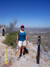
I woke up this morning, and found the morning to be exceptionally pleasant. Sooooooo, I said to myself, "How about going for a hike this morning?" After all, I haven't been hiking in a while. I got myself ready, dropped my son off at football practice and headed over to the trail closest to my home, the LV Yates Trail. And, guess what? It was gorgeous out!! And it felt really, really nice being out there. Gosh I miss our hikes!!
Showing posts with label Hiking. Show all posts
Showing posts with label Hiking. Show all posts
Saturday, August 16, 2008

Friday, May 30, 2008
Payson


Today we drove up to Payson and visited a few very cool spots. First we stopped at the Knotty Pine Cafe for breakfast...very tasty. Then we went to the Tonto Natural Bridge. This place is amazing!! Truly amazing. We spent quite a bit of time there hiking and exploring God's beautiful creation. The hike down was very easy, but going through it became a little bit more challenging. I was the first to bite-the-dust there, thankfully nothing major though. :0)
Next we headed over the the Water Wheel and explored quite a bit there. Also a very nice place. You can't really tell from when you get there initially, until you begin hiking in. We visited a couple of swimming holes and just took nature in. We had also packed a lunch, and enjoyed it while there. Both Grover and Dan (Tracy's hubby) bit-the-dust there. Tracy was the only one to leave Payson without any mishaps!! :0)
We headed back into to wn around 4:30ish. Whew!! Thankfully we were headed the opposite direction than most of the traffic, and made it home at a descent hour.
These are definitely places I'd like to visit again, and highly recommend that you all visit.


Friday, May 16, 2008
Estrella Mountain Rainbow Valley Trails (East & West)
 We hiked at a different park today. Traveled all the way to the west side to take on the Rainbow Trails. Getting there wasn't too bad since we were traveling against the traffic. The hike included both east and west Rainbow Valley Trails, part of the Toothaker trail, and part of the Gadsden Trail for a total hike of 9 miles in 4 hours....not bad...ehh! Our plan was to get started around 7:30 but we ended up starting about 7:50 and ended at 11:45. We started the hike on the west end, which was a good thing since it appeared to be the most strenuous in my opinion. But what exactly makes the hike strenuous? The book categorized the hike as moderate, but the park map included strenuous in its description. Anyhow, some of the challenges we experienced on this trail that we hadn't on the others were the rocks along the trail...tons of rocks, and the dirt was very loose, so we had put on quite the balancing act.
You will also notice the "snakes are out" caution sign, which made me feel particularly vulnerable. The last thing I wanted to see, was one of those rattlers, but thank God we didn't....WHEW!!!
It was quite hot, but occasionally there was a cool breeze to help keep us going.  There were a few times that I wondered, "what was I thinking in agreeing to do this long of a trail again?" Then I realized, those thoughts came a little too late. :0)
Estrella Mountain Park is not a bad area, during our hike we experienced a few nice valleys...lots and lots of Saguaros. Oh, and lots of ants, there were ant holes all over the place. Also, how could I forget too mention...other types of holes...BIG holes (like burrows)...don't know exactly what live in them, and certainly did not want  to find out. Towards the end of our trail, we came across one particular hole that looked almost like an ant hole, but had rocks around it which appeared to be wet...very strange, we weren't sure what had built it. Being curious and all, I thought it was a great opportunity for a Kodak moment. So take a look, and if you know what it's from, give me a holler.
Next weekend is Memorial Day weekend, and we're taking a break from our hikes. But we will resume the weekend after that and will let you know all about it. We've not decided where we will be hiking, but since it's getting hotter, we've tossed around the idea of driving up north for the day...dunno yet...BUT will keep you informed.
Saturday, May 10, 2008
McDowell Mountain Regional Park
This Friday we hiked the McDowell Mountain Scenic Trail near
near
Fountain Hills. The hike was about 4.3 miles, and it took us about 1.5 hours to hike it. Not bad, ehh?? Well, the trail was relatively flat, just a few little hills, so that made it a lot easier for us. The area was not bad, didn't have as many pretty views as some of the other hikes. And, also, there was a lot of poop along the trail, horse poop, dog poop, more horse poop, etc, etc....well you get the picture. Anyhow, getting around the poop was probably the most challenging part of our hike this Friday.  Grover's friend, Tracy, went along with us again. Whew...thought we had scared her after last week's hike. She sure had some pretty nasty looking blisters from South Mountain's hike, though. But, she seems to be quite the trooper, and decided to come along.
Once we were done with this trail, we decided to go check out the fountain, and walk around the park, which is about 1 mile. Since we were already in the vicinity, might as well check things out. The park was full  of lively children playing and running through the water fountains along with a group of seniors having a picnic. The fountain did go off while we were there, and we had an opportunity to get some lovely
  pictures. Oh, and we got so see a mama duck with all of her little ones, I counted 12, but Grover says 13. I don't know, those little suckers were hard to keep track of, going under the water and making it more difficult for us to count. Once we were done there, we headed back into town, and went out for Mexican food....YEAH!!!! This was an opportunity for us to replenish ourselves, and eat 3x - 4x the calories we had just burned. Afterward, we went to the movies and watched Baby Mama....mmmm....personally, not a very good movie. But I'll let you all decide for yourselves about that.
Friday, May 2, 2008
South Mountain's Alta and Bajada Trails
Friday, 5/2, we hiked South Mountain (SM) again. This has been probably the hardest trail so far due to its 1,200 feet elevation gain and distance...by the time we were done we hiked around 9 miles. Access to the TH was closed so we had to park a bit further down the road which increased our hike by at least 1 - 1.5 miles. The trail is located in the Ma Ha Tuak Range within SM. We did not see not one soul out there (probably not as crazy as us). It sure was pretty up there though. First we had to cover a number of switch-backs going up the south side of the mountain and then hiked along the south side. Eventually we crossed over to the north side of the mountain and had a fabulous view of city. We proceeded to hike along the north side and then encountered a few other switch-backs which took us back to the south side. Once on the south side, we began to descend, and the rest was fairly flat, but looooooooooong, very looooooooong. We had a new hiking buddy today, Traci, Grover's friend from Michigan. We were all pretty whooped by the time we were done. Actually, who am I kidding, we were whooped before, but we had to keep going to get to the car. And, YES, well felt very proud...VERY, VERY PROUD!!!
Then we headed over to Tempe to try some vegetarian food at the Green Restaurant. It was very tasty...
Forgot my camera, so no pictures this time. Although, I did take some with my phone camera, but they didn't come out very good.
Piestewa Peak - 1A Perl Charles Memorial Trail


Friday, 4/25 we hiked a new trail in the Piestewa Peak area, Trail 1A. The trail itself was not bad, just long. It started west of the 51 and we had to take a tunnel under the 51, that was kind of freaky, saw some interesting graffiti on the way. This has probably been my least favorite of the ones we've done so far. Just took a few pictures...not as pretty as the others.
There were several other trails that connected to this one, so we had to be careful not to get lost....hmmm....I mean turned around. As you can see from the picture below, we now carry the handy dandy hiking book for just these types of occurrences.

Sunday, April 20, 2008
Squaw Peak

 This Friday we hiked at Squaw Peak for the third time. We have been hiking a trail called the Freedom Trail. It is essentially the circumference of Squaw Peak, and does include about 1/3 of the Squaw Peak Summit trail. My hiking buddy suggested that once we get to the area that connects with the Summit Trail we should hike up all the way to the top of Squaw Peak. I was not very willing to do this. By that time, we had already hiked over 3.5 miles, and I was somewhat tired. But of course he was trying to encourage me. He said, "you'll feel so proud once you're up there." I quickly responded, "I already feel proud, I don't need to feel any prouder." Yes, I know, I sounded a bit grumpy. That's exactly what he said. Actually he said I was being grouchy. Can you believe that? The nerve!!! Well, guess what? I did it. And this is what it looks like from the top. And he was right. I did feel proud! :0)


Friday, April 18, 2008
South Mountain


We've hiked South Mountain twice so far, and it's been quite interesting to say the least. The first time we hiked it, 2 weeks ago, our plan was to hike Mormon Loop, which is a balloon shaped trail that begins at around 24th St & Baseline. Notice how I said "intended". Well, we were not aware that there was also a Mormon Trail which connects to Mormon Loop and also the National Trail. As a result, we ended up hiking all of the Mormon Trail and Mormon Loop and part of the National Trail. (We made a few wrong turns on the way!!) So this increased our hiking distance to twice of what we originally intended. Thankfully, as some point (maybe a mile or so) while on the National Trail heading west, I mentioned to my hiking buddy that I thought we were going the wrong way. We debated a bit and eventually turned back. Thankfully, it was a smart move. So what should have been maybe a 1.5 - 2 hr hike turned into a 3.5 hr hike. Yikes...I know...I know. Now one thing you have to understand is that he is the guy with the book, so I trust that he's got these trails memorized by the time we get to the trail head. BIG mistake. But gullible as I can be, I let him lead (he sounds so convincing when he says "now we have to turn left", etc). I should have learned this from a conference we both attended years ago in Kansas City. We were going to Jacks Stack (bbq place) for dinner. It is about 3 blocks away from the hotel. Not bad, I thought. And my buddy said he knew where it was located. Ok, we set off to Jacks Stack. Well, about 6-7 blocks later, we get there. He took us through the scenic route!!! But anyhow, without digressing too much, I was pretty tired by the end of that hike. So, we went back the following week, and did almost the same trail, but started at a different trail head, and hiked the trail from the opposite direction...much easier that time. All in all, great hikes, and the area is beautiful. We had to pass through a few very cool places. And of course, also admired our precious city with its pollution. Gosh, really is an eye opener to what we breath in daily! Ughh!!!


This is the famous Fat Man's Pass. Whew, thankfully, I could still make it through!!!
Hiking 101 (for us that is)

My buddy and I have recently taken up hiking. He's got this great book: 60 hikes within 60 miles, or something like that. Anyhow, we are determined to do all 60 hikes. Well, maybe not all 60, but at least 30. Well, that may even be a stretch, since we're fairly new at this. So, I'll just update you weekly, and let you know how it's going. Seeing as how each new trail we try, brings a new sense of adventure. First we have to familiarize ourselves with the trail, so we usually have to hike it at least 2-3 times to do that. Then familiarize ourselves with the additional trails we encounter, seeing as how we end up getting lost, hmmm I mean not lost, but maybe just a bit turned around. Whew...good thing we carry plenty of water with us! Anyhow, point I'm trying to make here, is that at this rate, it may take us a while to get through a number of those hikes. But bear with me, I will keep you posted on the progress. :-) Oh, and by the way, this is my hiking buddy, Grover.
Subscribe to:
Posts (Atom)